Hand-drawn Lotting Maps: A tale of two land surveyors and their close family relationship
By Marjorie Strong and Paul Carnahan
Two of the treasures in the Leahy Library are bound collections of early, hand-drawn lotting maps of northeastern Vermont towns by John W. Chandler of Peacham and another by Samuel C. Crafts of Craftsbury. Although these three volumes have long been shelved near each other in the library’s vault,
the exact relationship between them has not been understood until recent research in digitized newspapers. revealed their interesting history. John W. Chandler was born on 1 June 1767, the son of John and Mary (Chandler) Chandler (Mary Chandler was Samuel Chandler Craft’s aunt; more on that later).
The family moved to Peacham, Vermont, in 1796, where John became involved in land surveying. This work gave him insight into the value of land, and he became a successful land speculator, particularly in Essex and Caledonia Counties. He was also treasurer of the town of Peacham for 34 years, was elected to the state legislature for five terms, and served as judge of the Caledonia Probate Court for four terms. He died on 15 July 1855. In 1921, George Chandler Coit donated two volumes of Chandler’s land records, including lotting plans that show the original grantees of the land, to the Vermont Historical Society. The donation made front page news in local newspapers with the headline, “Valuable Surveys Given to Historical Society,” and opined, “this gift from Mr. Coit is the most valuable one the Society has received for some time.” Franklin H. Dewart, a well-known 20th century surveyor, writes in the introduction to volume two of the State Papers of Vermont published in 1922, “These books...exhibit a conscientious precision and exhaustive thoroughness
and such industry as to us degenerate moderns are almost unknown.”
Chandler purchased most of the papers of James Whitelaw, Vermont’s second Surveyor General, after Whitelaw’s death in 1829. Consequently, many of Chandler’s maps may be based on Whitelaw’s original town surveys, at least in volume two, which dates between 1830 and 1855. The maps in volume one have a much less finished feel to them, appearing to be working documents rather than maps drawn for legal reference in land cases.
A contemporary of Chandler’s was Samuel Chandler Crafts, his cousin. Crafts was born in Woodstock, Connecticut, on 6 October 1768, son of Ebenezer and Mehitable (Chandler) Crafts. He graduated from Harvard University in 1790 and settled in Craftsbury in 1791. He was elected town clerk in 1799 and served until March 1829 and held a variety of public offices: he was a member of the U.S. House of Representatives from 1817 to 1825, was elected Governor of the State of Vermont in 1828 (he served until 1831) and was appointed to serve in the US Senate from 1842 to 1843. He died on 9 November 1853.
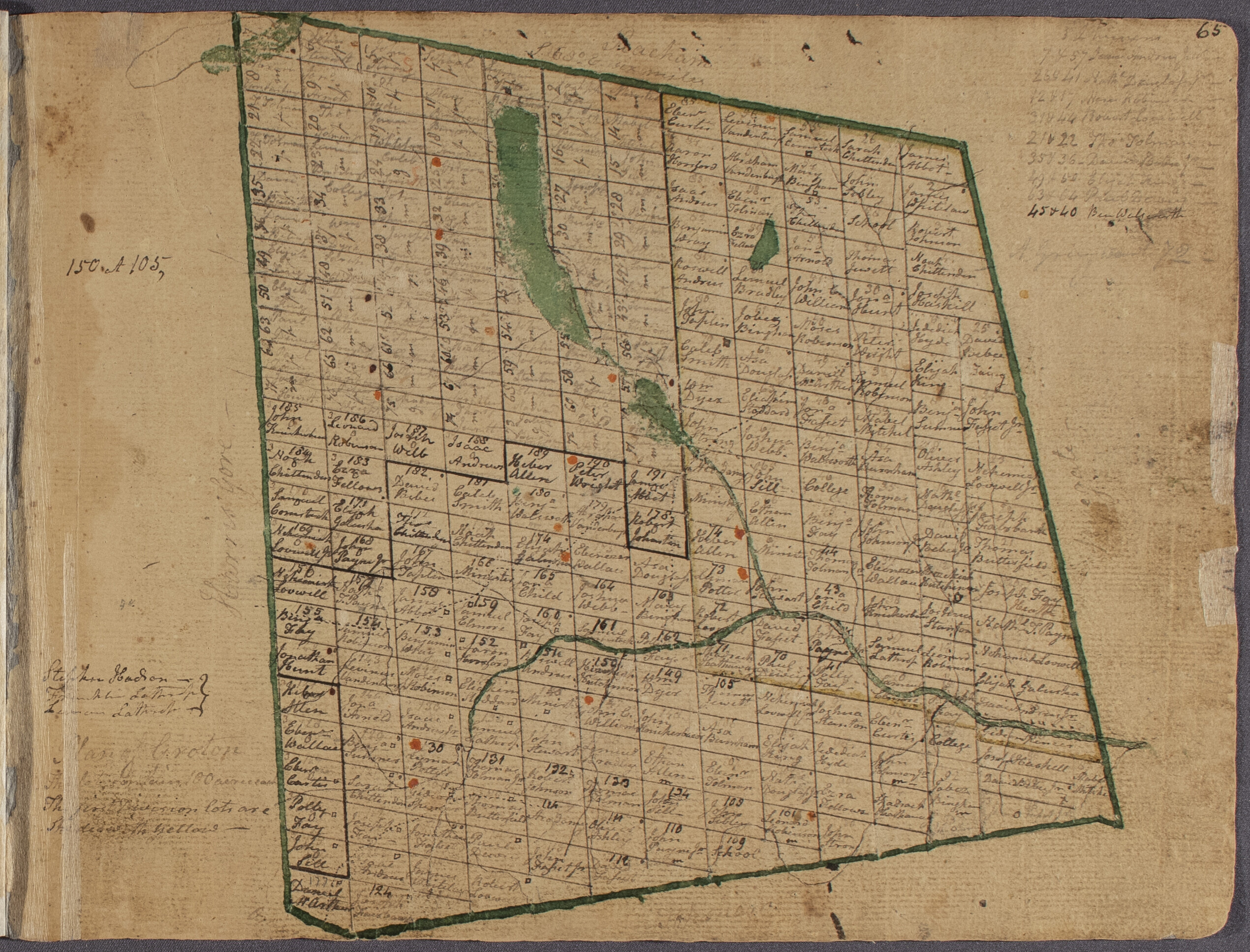
Crafts’ atlas appears to fall chronologically between the two Chandler atlases, dating between 1820 and 1830. Because of the close family relationship between Crafts and Chandler, Crafts’ maps may be copies of Chandler’s, and many have less detail. The exceptions are the map of Craftsbury, and surrounding towns such as Albany, Eden, and Hyde Park, where Crafts has noted more geographic features, primarily hills. Interestingly, Crafts’ map of Peacham, Chandler’s hometown, is also more detailed.
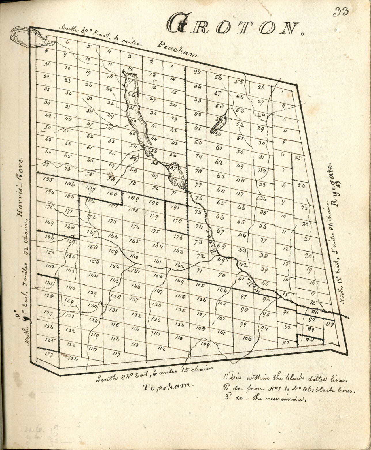
Lotting map of Groton created by Samuel Chandler Crafts in the early 1800s. Image: Vermont Historical Society
Samuel Crafts’ lotting maps came to the attention of the State of Vermont around 1910, when a law was passed “...to provide for the publication of state papers,” which explicitly mentions the inclusion of Crafts’ book of plans in the volume. The Crafts plans were not published by the state but were indexed in the published State Papers. The plans at that time were located at the Craftsbury Academy, and in 1968 they were loaned to the Vermont Historical Society for safe keeping. After over 40 years of stewardship, the plans were formally donated to the VHS in 2019.
In 1922, as the state was publishing a volume of town charters, a reporter for the Barre Daily Times opined that “The Crafts book pales beside Chandler’s … because there now arises a strong suspicion that Crafts copied from Chandler’s, which had been so long in use that it had to be re-bound in 1830.”
Now, after 92 years, the maps in volume two of Chandler’s atlases have been conserved and rebound thanks to the generosity of VHS member William Steele. You can view scans of Chandler’s maps on Digital Vermont. You can also see scans of Crafts’ maps on Digital Vermont.
This article originally appeared in the Summer 2022 issue of our member magazine, History Connections. To get it and support the Vermont Historical Society, sign up as a member.